Bourbon Pilgrim
The moment usually arrives on a quiet lane somewhere past the second distillery. The tasting notes are still on your tongue, the next tour starts in forty minutes, and your phone, which had four bars at breakfast, now shows one, then none, while the map on the screen turns into a grey grid with a blue dot floating on nothing. Nothing is broken. That is simply what cell service on the Bourbon Trail is like once you leave the cities, and it is the one planning detail almost no itinerary mentions. Below is where the signal actually holds, where it drops, why your GPS keeps working after your bars vanish, and the ten minute download routine that makes the whole question stop mattering. If you would rather hand the navigation to someone who already knows these roads, our ranking of the best bourbon tours from Louisville scores the guided days that carry the driving, the routing and the bookings for you.
Where the signal holds and where it drops
| Place | What to expect | What it means for your day |
|---|---|---|
| Downtown Louisville and Whiskey Row | Strong signal on every major carrier | Everything works, including rideshares, tickets and restaurant bookings |
| Lexington and Versailles town centers | Strong in town, thinner on the horse farm lanes outside | Load the Woodford Reserve route before you leave town |
| Bardstown town center | Workable signal in town | Bookings and maps load, sometimes slowly at peak times |
| Rural Nelson County, including the roads to Loretto | Unreliable, per the James B. Beam Distilling Co. visitor guide | Offline maps are mandatory, and rideshares are not a plan |
| Frankfort town center | Workable signal in town | Buffalo Trace check in and gift shop visits run normally |
| Lawrenceburg, home to Four Roses and Wild Turkey | Patchy, with waits and dead stretches on the approach roads | The back road between Four Roses and Wild Turkey is a known drop zone |
| Loretto, home to Maker's Mark | Among the weakest signal on the main trail | Save the address and the tour time before you leave Bardstown |
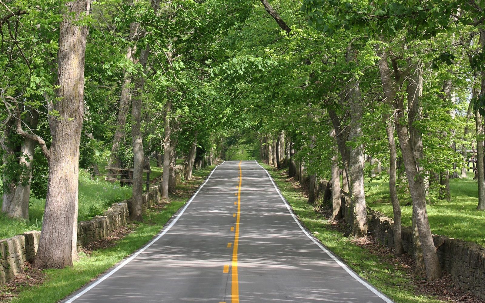
Louisville is a real city signal environment. The downtown distilleries, Angel's Envy, Michter's Fort Nelson, Rabbit Hole, Old Forester and the Evan Williams Bourbon Experience, all sit within walking distance of one another, and your phone behaves there exactly as it does at home. Our Louisville trailhead guide maps that walkable cluster. Lexington behaves the same way inside the city, then changes character fast. Old Frankfort Pike, the scenic byway in the photo at the top of this guide, runs for about 15 miles between Lexington and Frankfort beneath a canopy of hardwood trees and between dry laid limestone fences, per the Federal Highway Administration, and a tree canopy over a two lane road in a creek valley is a textbook recipe for a fading signal.
The countryside numbers explain the pattern. Kentucky covers 40,408 square miles, per FCC data, and no carrier covers all of it. AT&T has the widest 4G footprint at about 73 percent of the state land area, Verizon follows at about 70 percent, and T-Mobile covers about 55 percent, per FCC data. The 5G picture is thinner everywhere. T-Mobile leads at about 45 percent of the state, AT&T covers about 41 percent and Verizon about 21 percent, per FCC data. Read those numbers the right way. A carrier can honestly claim strong statewide coverage while still leaving the exact valleys where distilleries sit uncovered, because distilleries were built beside creeks and limestone springs, down in the low ground where water was, not up on the ridges where towers work best.
Nelson County deserves its own warning because Bardstown sits inside it. Cell service in Nelson County is unreliable, per the James B. Beam Distilling Co. visitor guide, and the same guide tells visitors to download maps before leaving the hotel and to print the cluster sheet for the day. The Beam distillery itself sits at 568 Happy Hollow Road in Clermont, per the distillery, about 30 minutes south of Louisville and about 25 minutes north of Bardstown, so the most visited approach road in bourbon country crosses the county where your phone is least trustworthy. Maker's Mark in Loretto, about 35 minutes beyond Bardstown, sits deeper in the same countryside, and signal on the lanes around it is the weakest most visitors meet on the whole trail.
Why the signal drops in bourbon country
Four causes stack up, and all four are visible from the car window. First, terrain. Cellular networks are notoriously unreliable in the deep valleys and limestone ridges surrounding rural Kentucky distilleries, and a signal that has to cross a ridge or climb out of a river valley arrives weaker or not at all. The Kentucky River cuts the gorge below Wild Turkey in Lawrenceburg, Glenn's Creek runs past Woodford Reserve in Versailles, and Stitzel Creek shaped the Maker's Mark grounds in Loretto. Every one of those pretty approaches is a dip in the land, and dips are where bars go to die.
Second, distance between towers. Rural counties carry fewer towers per square mile because they carry fewer people, so each dead stretch lasts longer than a city dropout. Third, buildings. Thick limestone walls and steel racking inside rickhouses weaken signal indoors, and the fastest 5G signals have the most trouble passing through solid materials, which is why a phone that worked in the parking lot can stall at the tasting bar. Fourth, crowds. The trail drew about 2.7 million visits in 2025, per the Kentucky Distillers' Association, and September festival weekends and fall Saturdays load the rural towers that do exist with far more phones than a normal weekday. A route that held signal on a Tuesday morning can still drop your call on the Saturday of the Kentucky Bourbon Festival.
Your GPS is fine. Your map is the problem.
This is the distinction that saves trips, and most visitors have it backwards. Your phone finds its position from GPS satellites, not from cell towers. The GPS receiver in a phone listens to satellites overhead and works with no bars at all, and phones are typically accurate to within about 5 meters, or 16 feet, under open sky, per GPS.gov. That blue dot is honest even in a dead zone. What the phone cannot do without signal is fetch the map around the dot. Roads, place names, search results, live traffic and new routes all arrive over the internet, one small piece at a time, as you move. Lose signal with nothing saved and the app has your position but no picture to put it on, which is the grey grid moment from the start of this guide.
Downloaded maps close that gap completely for driving. An offline download stores the roads and places for a chosen area on the phone itself, so turn by turn driving directions keep working inside that area with no signal at all. The limits are worth knowing before you rely on it. Offline Google Maps gives driving directions only, with no walking, cycling or transit directions and no live traffic, per Google. Downloaded Google Maps areas expire after about a year if they are not updated, per Google, so a map saved for last year's trip may need a refresh on WiFi before this one. Apple Maps added offline maps in iOS 17, per Apple, and it covers driving and walking directions inside the saved area. Neither app can book a rideshare, load a ticket barcode that lives only in your email, or message your hotel while offline. The download fixes navigation. The screenshots in the next section fix everything else.
The ten minute routine before you leave the hotel
Do this once, on hotel WiFi, before the first rural day. It takes about ten minutes and it converts every dead zone on the trail into a non event.
| Step | Do this | Why |
|---|---|---|
| 1 | Download four offline areas, Louisville on its own, Bardstown on its own, Frankfort and Lawrenceburg together, and Lexington and Versailles together | Each cluster fits in its own download, and together they cover every main trail road |
| 2 | Save each distillery address as a starred place inside the maps app | Search works offline for saved places even when general search is thin |
| 3 | Screenshot every tour confirmation, with the start time and the address visible | Ticket barcodes and confirmation pages that live in email or a browser cannot load in a dead zone |
| 4 | Screenshot your hotel address and your dinner reservation | The drive home at night is when a wrong turn costs the most |
| 5 | Tell your group the plan in words, first stop, second stop, lunch town | A plan the whole car knows survives a dead phone battery as well as a dead zone |
| 6 | Charge a small battery pack and put it in the car | Offline navigation with the screen on drains a phone faster than most visitors expect |
Two addresses are worth saving exactly as the distilleries print them. James B. Beam Distilling Co. lists 568 Happy Hollow Road, Clermont, KY 40110, per the distillery, reached from I 65 Exit 112, and Louisville to Clermont is about 30 minutes while Clermont to Bardstown is about 25 minutes. Buffalo Trace sits in Frankfort, about 50 miles and 55 minutes from Louisville, and Louisville to Lexington is about 80 miles and 75 minutes, per the Bourbon Trail planning map. The distilleries spread across six regions and more than 200 miles of countryside, per the same planning map, and stops on a rural day routinely sit 30 minutes or more apart on winding roads. Our drive time guide to how far apart the Bourbon Trail distilleries are puts every cluster pair in miles and minutes, and it is worth reading alongside the downloads, because knowing the next leg is 35 minutes tells you how much dead zone to expect.
Paper still earns a place in the glovebox. The Kentucky Bourbon Trail Welcome Center inside the Frazier History Museum in Louisville hands out trail maps, and the Beam visitor guide publishes a printable one page map with cluster addresses and drive times that is designed to be printed before you leave the hotel. A printed sheet never needs a signal, never runs out of battery, and settles the one argument every car has in a dead zone, which road the group actually agreed on.
What breaks when the bars vanish
Navigation is only the first casualty. The second is the rideshare plan, and it fails twice at once. Booking a car needs signal, and the rural counties have few drivers to send even when the app loads. Waits of half an hour or more are common around Lawrenceburg, rural Nelson County coverage is functionally unavailable, and one group of travelers in our transportation research waited two hours in the countryside with no car ever coming. A single Uber from downtown Louisville to the Beam distillery in Clermont runs $60 to $80 each way, per the Beam planning guide, on the rare occasions one is available for the run. Our Bourbon Trail transportation guide prices the lanes that do work, region by region.
The third casualty is the small stuff that quietly runs a modern trip. Tour check in pages that will not load. A restaurant that cannot be called to say you are running late. A gift shop bottle release post you never see. Messages between two cars in a group that split up at a junction. None of these ruin a trip on their own, and all of them are prevented by the same habit, load it, screenshot it or say it while you still have bars. Visitor centers help here. Distillery visitor centers and hotels offer WiFi, so the parking lot of your next stop is the natural place to reload the afternoon route, pull up the dinner booking and send the messages that waited. Treat each stop as a signal stop as well as a bourbon stop and the dead stretches in between stop mattering.
Safety deserves one plain paragraph. In a real emergency, call 911 first and worry about bars second. Emergency calls can connect through any available carrier network, not only your own, per the FCC, so a phone showing no service on its own carrier can still complete a 911 call through a rival network that reaches the spot. What no phone can do is invent a network where none reaches at all, which is one more reason the group should know the route in words and the car should carry water, fuel and a charged battery pack on rural days.
The easy way out, let a local drive
Every problem in this guide shares one root, a visitor navigating unfamiliar rural roads with a phone that keeps going quiet. Guided days delete the root. The operator knows the Loretto lanes and the Lawrenceburg back roads without a map, holds the distillery bookings before signal ever becomes your concern, and drives while everyone in the group tastes. That is also why our guided versus self drive comparison keeps landing on the same verdict for couples and small groups. The guided fare usually beats the cost of fixing a self driven day that goes wrong.
| Guided day | Price | Duration | Group | What it removes |
|---|---|---|---|---|
| Mint Julep Experiences full day | From $289 per person | 9 hours 30 minutes | Up to 22 | Navigation, bookings and driving across Buffalo Trace, Bulleit and Rabbit Hole, with admissions included, per its Viator listing |
| Ky Bourbon Tours customizable day | From $189 per person | 6 to 8 hours | Up to 11 | Route planning entirely, with Buffalo Trace guaranteed plus 2 stops you pick from more than 20, per its Viator listing |
| B and C Bourbon Experience Tour | From $249.99 per person | 7 to 9 hours | Up to 12 | The booking scramble, with 3 distilleries you pick from a list of 9 and the reservations made for you, per its Viator listing |
| Private transport package | $399 per person | Up to 10 hours | Your group only | The driving and the routing, while you keep your own tickets and your own route, per its Viator listing |
Compare the full field in our best bourbon tours from Louisville comparison before you book, and if nobody in your group wants to navigate or drive at all, our guide to Bourbon Trail designated driver options ranks every working solution, from a rotating sober driver to a walkable downtown day that needs no car and no signal at all.
Check the Mint Julep Experiences full day on Viator →
Check the Ky Bourbon Tours customizable day on Viator →
If you drive yourselves anyway
Plenty of groups drive the trail happily every week, and the ones who enjoy it share the same habits. They download before they leave, not at the first dead zone. They start the rural day with a full tank, because gas stations thin out on the same roads where signal does. They agree the order of stops out loud before the car moves, and they keep the printed map in the glovebox for the junction arguments. They load the next route in each distillery parking lot while the visitor center WiFi reaches the car. And they plan the last rural leg to finish in daylight where they can, because a missed turn on an unlit county road at night, with no signal to reroute, is the one version of this problem that stops being funny.
Do the downloads, save the addresses, screenshot the tickets, and cell service on the Bourbon Trail becomes what it should have been all along, a footnote to the trip instead of the story you tell about it.
Let someone who knows the back roads do the navigating. Compare the guided days that carry the driving, the routing and the bookings:
Check the Mint Julep Experiences full day on Viator →
Check the Ky Bourbon Tours customizable day on Viator →
Affiliate links. If you book, we may earn a commission at no extra cost to you.